JAMES BAY DISTRICT PLATFORM

CHABINOCHE

District-Scale, Early-Stage Exploration Property in James Bay

Chabinoche is part of CDN Maverick’s James Bay platform, with lake-sediment anomalies, mapped pegmatites, regional structures, and target-ranking work supporting continued field evaluation.

PROPERTY SNAPSHOT

756

ACTIVE CLAIMS*

41,104.68

HECTARES*

Exploration Stage

Early-stage exploration

Key Themes

• Lake-sediment anomalies

• Mapped pegmatites

• Regional structures

• Target-ranking work

* As of June 30, 2026

LAND POSITION

756 claims · 41,104.68 ha

EXPLORATION STAGE

Early-stage exploration

REGIONAL STRUCTURES

Favourable corridors identified

PEGMATITE CONTEXT

Mapped pegmatites in multiple areas

INDICATOR ELEMENTS

Selected samples with elevated indicators

RELATED FOCUS

Nottaway is the current technical focus

WHY CHABINOCHE MATTERS

Multiple reasons to keep advancing early-stage work.

District-Scale Position

A large, contiguous land position within James Bay provides exposure to multiple prospective corridors and geological settings.

Target-Ranking Work

Integration of lake-sediment data, mapped pegmatites and regional structures supports a disciplined pipeline of targets.

Field Follow-Up Warranted

Early indicators across a large area justify continued field checking to test priority targets and refine understanding.

CHABINOCHE IN CONTEXT

A key part of CDN Maverick’s James Bay land package.

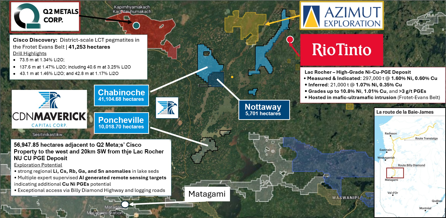
Chabinoche sits along prospective corridors within the the James Bay region approximately 60km north of Metagami. 

Chabinoche forms part of CDN Maverick’s James Bay platform, shown in relation to Nottaway, the company’s current technical focus.

WHAT WE’VE LEARNED TO DATE

Lake-Sediment Anomalies

Multiple lake-sediment samples returned elevated pathfinder element responses across several areas.

Mapped Pegmatites

Pegmatites are mapped in multiple areas within the property, consistent with regional trends.

Regional Structures

Regional-scale structures and lineaments are present and may provide prospective conduits.

Target-Ranking Work

Datasets are integrated to rank targets and prioritize areas for field verification.

WHY FURTHER WORK IS WARRANTED

Early indicators across a large system.

The combination of lake-sediment anomalies, mapped pegmatites, regional structures and target-ranking work highlights multiple areas of interest. The property remains early stage, and additional field work is required to evaluate the nature and scale of mineralization potential.

Early-stage property with significant exploration potential

Large land position with multiple prospective settings

Systematic approach to data integration and target definition

Field programs designed to test and refine priority targets

RELATED JAMES BAY PROPERTIES

Explore our district-scale platform.

CURRENT TECHNICAL FOCUS

Nottaway

Our current technical focus with active target validation and field programs.

ALSO EXPLORING

Poncheville

Large land position with mapped pegmatites and AI-assisted target ranking.